I reached the top of the marshland climb, now in the shadow of the mountain before me.Tired, exasperated and weary. I finally spotted a gravel path up to the summit. The gravel however, on closer inspection wasn’t anything of the sort. Rocks and pebbles filled the path leading up the steepest part of the ascent where steps carved out of the rock took over. With the front fork in my right hand and my rear fork in my left I bent down and hoisted the bike on my bike. This is the only way I would reach the summit.
Over the past month, I have vacated my home in London and have been living in Yorkshire. Living between two family homes. One in a small village hidden in the Yorkshire Dales and the other just on the outskirts of the sometimes posh town of Harrogate. I have been spending my time enjoying the company of my family. A far cry from the hustle and bustle of London and riding my bike, a long way and quite often.
I have made it my mission to use my time away from work as productively as possible. Whether that was by bikepacking my way from London to Yorkshire (read about that journey HERE), starting this website to document my adventures, reading more books or simply enjoying what the local pie shop has to offer after a ride.
The Yorkshire Dales, is the heartland of the United Kingdom and a place I call home. The rugged, harsh, wild and picturesque landscapes, stretching across the middle of the country I was born in leaves anyone with a sense of adventure wanting more. Heather and moss colour the mountain tops, rare birds find their homes here and sheep outnumber humans. Their white bodies paint the fields in between the once bustling industrial trails far into the horizon (Sheep that is, not pale Yorkshire farmers). It is a far cry from my usual cycling spots in the Surrey Hills.
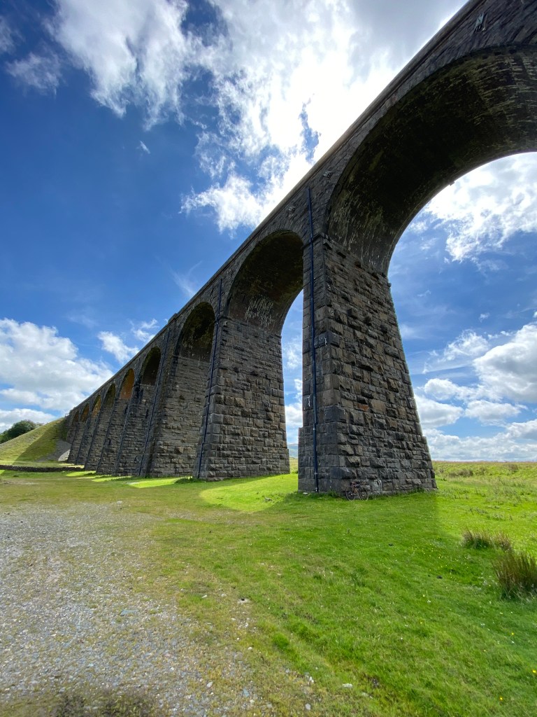
Since being in Yorkshire, I have covered over 400 miles and just shy of 42,000ft of elevation (the equivalent of climbing Mount Everest and then some), I have found abandoned lead mines, roads built by the Roman Empire, Stone Circles once used by The Druids, Viaducts built by 18th century engineering pioneers, waterfalls and rock pools formed by millions of years of erosion and tectonic movement and mountains my friends, lots of mountains.
I have really enjoyed exploring this area so when I saw the ARAF Trigonnee challenge on Instagram, I was all for it. The concept, simple enough, you have 24 hours to reach as many Trig points as possible. A challenge that would allow me to see more of this landscape with prizes. Win, win!
What the hell is a trig? Wikipedia – “A triangulation station, also known as a triangulation pillar, trigonometrical station, trigonometrical point, trig station, trig beacon, or trig point, and sometimes informally as a trig, is a fixed surveying station, used in geodetic surveying and other surveying projects in its vicinity.”
In layman terms – Historically, in order to map out a new town or village, trig points (concrete pillars) with metal tops used for attached theodolites (A optical instrument used to measure distances and angles) were installed on the largest, most advantageous mountains in the area. The trig points, used in triangulation with each other would give the surveyor the measurements needed to begin his planning. These days, trig points are not used for planning towns and villages, they are now used to plan walking, running routes and cycling routes.
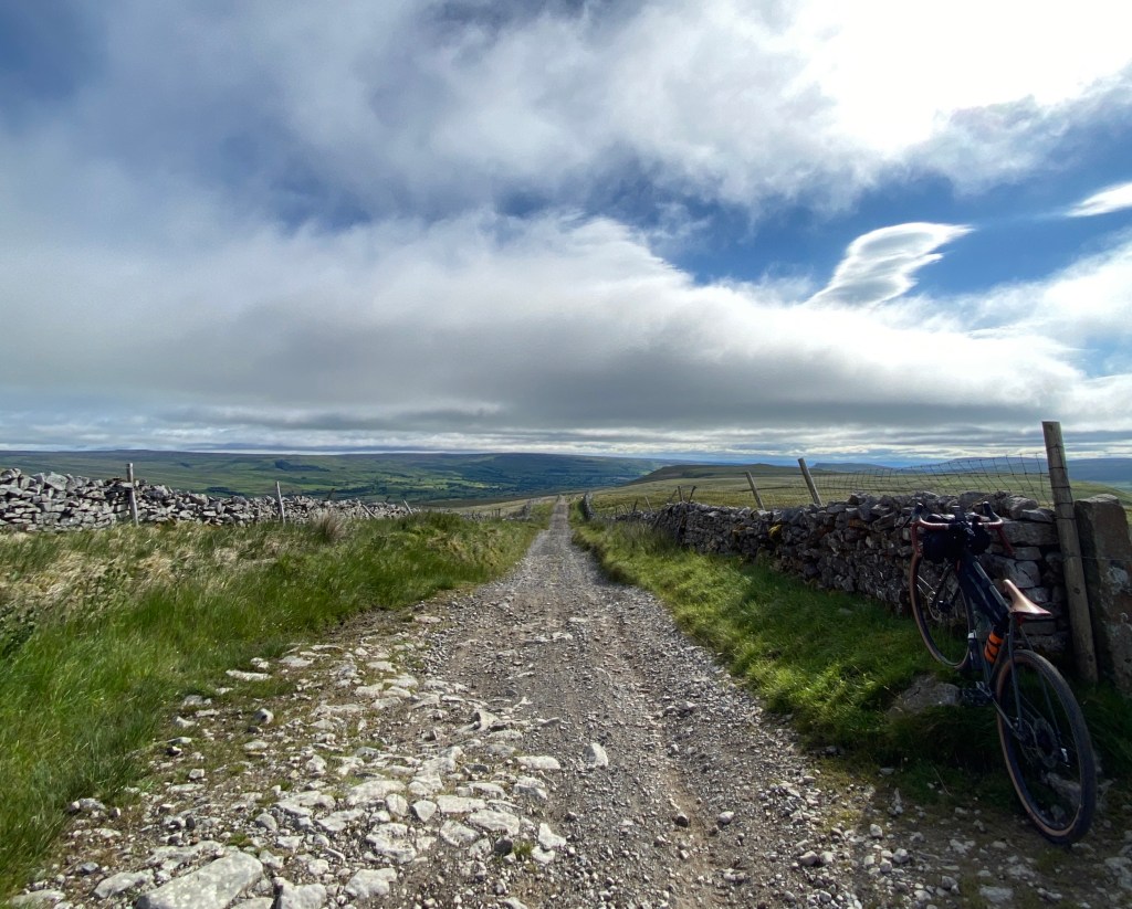
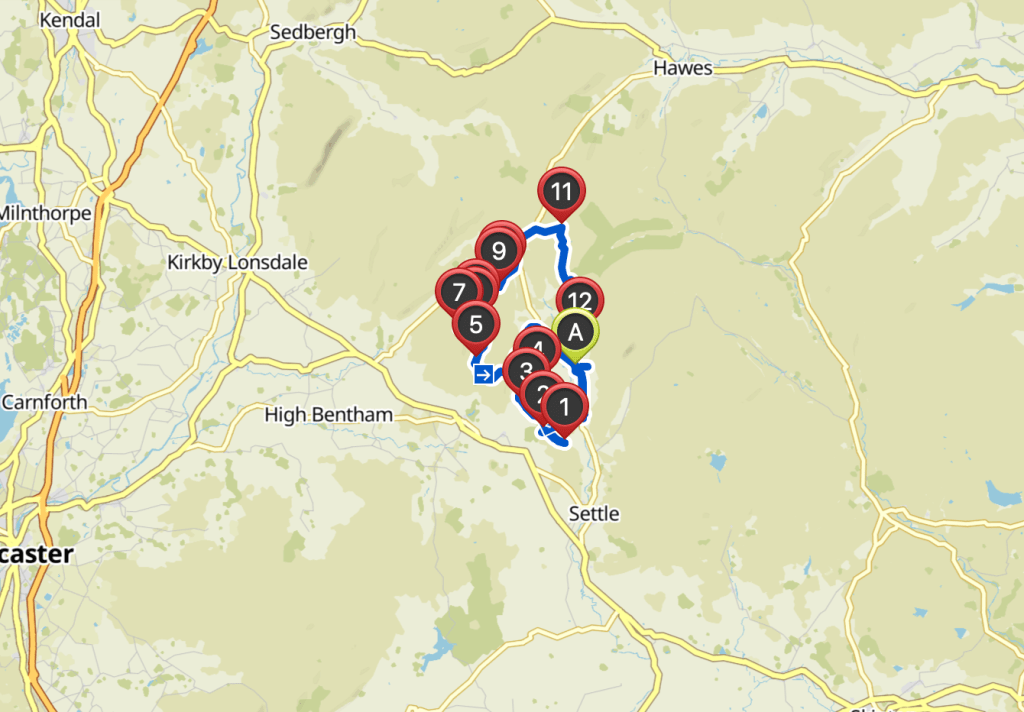
I set about planning my route using Komoot, alongside a map I found noting the trig points in the Yorkshire Dales. I pinpointed a location in which the most trig points fell in the smallest radius possible making the ride achievable, or so I thought. My target, 18-19 trigs in 24 hours. I decided my best option would be to drive to the village in the centre of the trig points and use this as my base. The car I would use would become my own personal re-fuel centre. A very similar plan to the one I used when cycling 311 miles in 24 hours for charity in 2019 and one that worked a treat. (Read about that challenge HERE)
The night before the ride, I stocked the car full of food and water and other bits and bobs that I may need (Chocolate milk and Jelly babies being the most advantageous). I cleaned the bike, did some small checks and decided I was ready to go.
My alarm sprung into action at 3am on the day of the ride, the weather man informed me it was to be one of the hottest of the year and it was already starting to feel that way. I arrived at the small village of Horton in Ribblesdale at around 4am and unpacked the bike, loaded it up with food and spares and pushed my first pedal strokes down the winding Yorkshire lanes. By my calculations, I figured I would be able to get five trig points done and get back to my car for an early lunch, have a rest, refuel and set off for another few hours, I would continue to do this until reaching my goal.
I reached Moughton, my first Trig point at 5:30am, the sun was rising over the Dales in the distance, moody blues and romantic yellows painted the skyline and I was very surprised at how bright it was. I should have set off much earlier. I took my pictures (A picture was needed for each trig point for the competition) with an air of confidence, one down, another 19 to go. My second trig point, however, was not so easy. It took me an hour to reach Sulbur and it soon became clear that all notions of this being achievable may have been a slight underestimate. The route to Sulbur was simple enough, follow the walking trails to the top of the hill. However, what Komoot does not take into account and more importantly what I did not take into account when planning this route were the pre-existing ground conditions.
The day before Trigonee 2020, a thunderstorm hit the Yorkshire Dales, dark clouds surrounding the quaint villages and it rained for hours on end. I was quite happy sitting inside watching the weather safe in the knowledge that tomorrow would be beautiful clear skies.
Well, it turns out using some simple mathematical equations, I shouldn’t have been so happy;
Rain + Moorland = Marshland.
Marshland + Bike + Human = Very hard.
Very hard + Very Warm Weather = Extremely Hard
Extremely hard + Mountain Climbing = Oh, well you get the idea!
The ascent to Sulbar was hard fought. The trail, sodden from the rain the day before, punished me with every pedal stroke. The slow trudge to the top expended my energy. I reached the top of the trail tired and in need of replenishment. At the summit of the mountain, I looked around and saw my next challenge. In order to reach the trig point I had to traverse the once ancient glazier. Now a scarred Limestone ground for at least 500m.
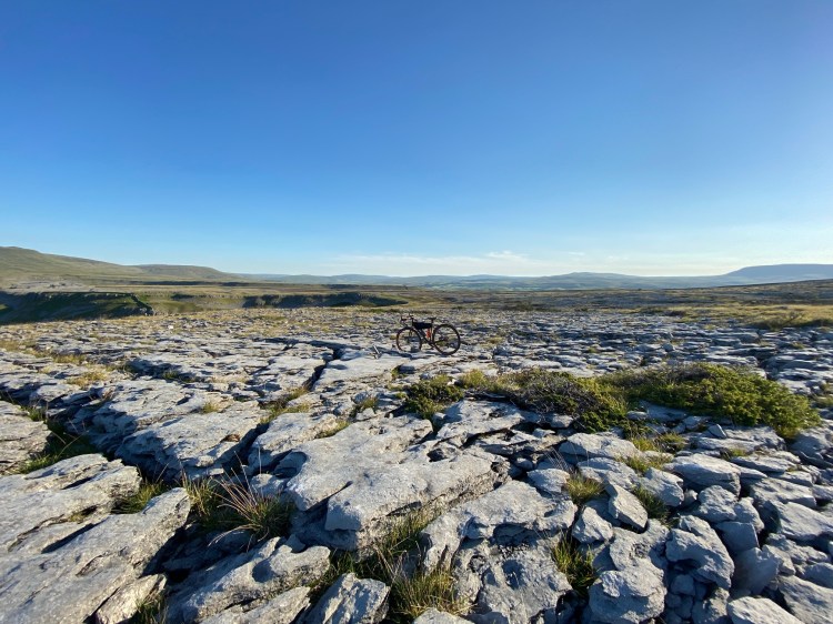
The Limestone ground shaped by years of erosion lay before me, cravasis between the stones awaiting the ankles of adventurers. The hidden microclimates between these housing rare flowers, the only remnants of the once ancient woodlands that once stood in this location. It wasn’t possible to push the bike over this. It would take far too long. My only option was to carry the bike over. I bent down and picked up the bike, tentatively I progressed. The pedal digging into my back, my arms bent back trying to balance the weight and with all I had, hoping from one rock to another, planning two rocks in advance making sure, hoping, I was as careful enough to avoid injury. This was a different type of adventure, my heartbeat was racing. After some time, I reached the trig point and admired the views. My breath returned after a few deep breaths and some welcome food and water. I relaxed for all of two minutes before looking back to where I had come from. That was my only way down.
The descent on this occasion was much faster than the ascent however my brakes didn’t enjoy it much. I carried the bike over the Limestone to the marshland and held on for dear life. The trail was fast and yes, furious. Avoiding the big rocks was the easy part, holding a good line on the sodden marshland was the challenge. My bike with tires suitable for gravel and road enjoyed the skidding more than I. The bike started creaking and making new noises. The wheels rolled over more and more rock formations and pebble paths, the steel frame flexing to keep up with the speeds and my bones shaking with every bump, my confidence was now taking a battering. Maybe undertaking such a route on a Gravel specific bike was not a great choice. Some suspension would have gone a long way in preserving my energy. Then came the squeak. There isn’t a lot in this world that annoys me but a squeaking bike is one of them. The high pitched moan following my ride now. I jumped off and applied some chain lube, hoping that would be the end of it.
Ingleborough was my next stop and following my route, I continued to follow the walking paths of the Pennine Way and now onto the Three Peaks route.
Turns out, this is when I met my nemesis. A climb that in hindsight, was unneeded, unwarranted and could have been easily avoided if I had spent a little bit more time planning the route.
But before I began this wonderful climb, there was just time to stop and wonder at Gaping Gill. Hidden in the southern shadows of Ingleborough, Gaping gill is a natural Limestone cave which holds Britain’s largest unbroken waterfall. The cave with a 98m deep descent was discovered and first descended in the 18th century. I stopped to look down, it was a long way. The waterfall sounded beautiful. I wanted to spend more time here. I looked at my route, and I had a long way to go. The Gill will have to wait for another day.

For a mile I followed the trail upwards, leaving the Gill behind and advancing to the Ingleborough summit. The sodden ground, much wetter than before obviously all fed into the waterfall I just left. This was on another level. My tires sank and squelched with every rotation. The ground, grasping at my wheels with every turn. My legs, now burning with the pressure brought on a sudden feeling of disappointment and anger, I wondered what the hell I was doing. In the distance I saw walkers, strolling along with ease up the trail to the summit of Ingleborough on what looked like a gravel path and with a quick zoom out of my Wahoo map, I realised this was the path I had to reach. That was the path my map had previously told me to leave, that was the path I should be on. I had just done a big loop of the area for no reason and spent most of my energy doing so. I laughed it off with gritted teeth, put some music on and pushed and pulled my way to the much needed solid ground.
I reached the top of the marshland climb, my thighs burning and my mouth dry, tired, exasperated and weary. I paused and looked back on the now naturous climb and shook my first. I was now in the shadow of the mountain before me. The path I reached however, on closer inspection wasn’t anything of the nice gravel accent I dreamed of just minutes before. Large Rocks and loose pebbles filled the path leading up the steepest part of the ascent. I attempted to ride as much as I could before the gradient looked up and my tires spun on the loose ground. It was that time again. And with the front fork in my right hand and my rear fork in my left I bent down and hoisted the bike on my back. This is the only way I would reach the summit. However this time, it was a long way, and upwards.
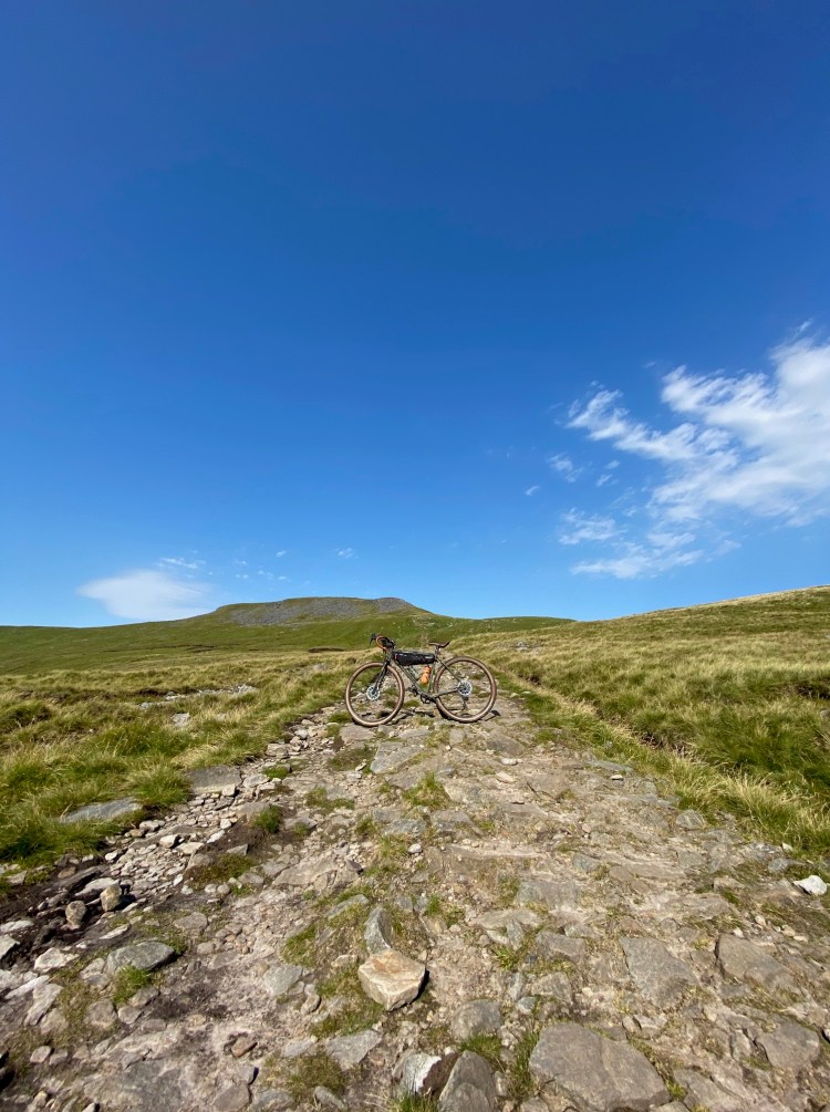
After half a mile I reached the steepest part of the ascent, now my progression was in the form of steps carved out of the rock face sometimes half a meter tall. I progressed slowly and carefully, every lunge awaking my muscles from my ankles to my neck. As a cyclist my legs take a good amount of battering so I am used to this but what I am not used to is carrying around 16kg of weight on my bike whilst doing so. A whole new level of pain and adventure.
The heat, more noticeable now as it reflected off the rock face became a contributing factor in my speed. The temperature was a steady 28 degrees and the sweat was falling from my face to the ground in front of me. Walkers, passing me in the opposite direction gave me a nod and a smile as they passed. A fell runner, notably one of the most craziest of all endurance sports due to its list of injuries that occur on a daily basis with the athletes told me;
“You’re carrying that all the way to the top? You’re a bloody nutter”
My confidence then took a turn, maybe I wouldn’t reach my target for the day, maybe I would just reach half of what I had intended but that was OK, this was a challenge, an adventure. Yes, I was a bit of a nutter and I was enjoying it. I had a new sense of energy and with that, I climbed to the summit.
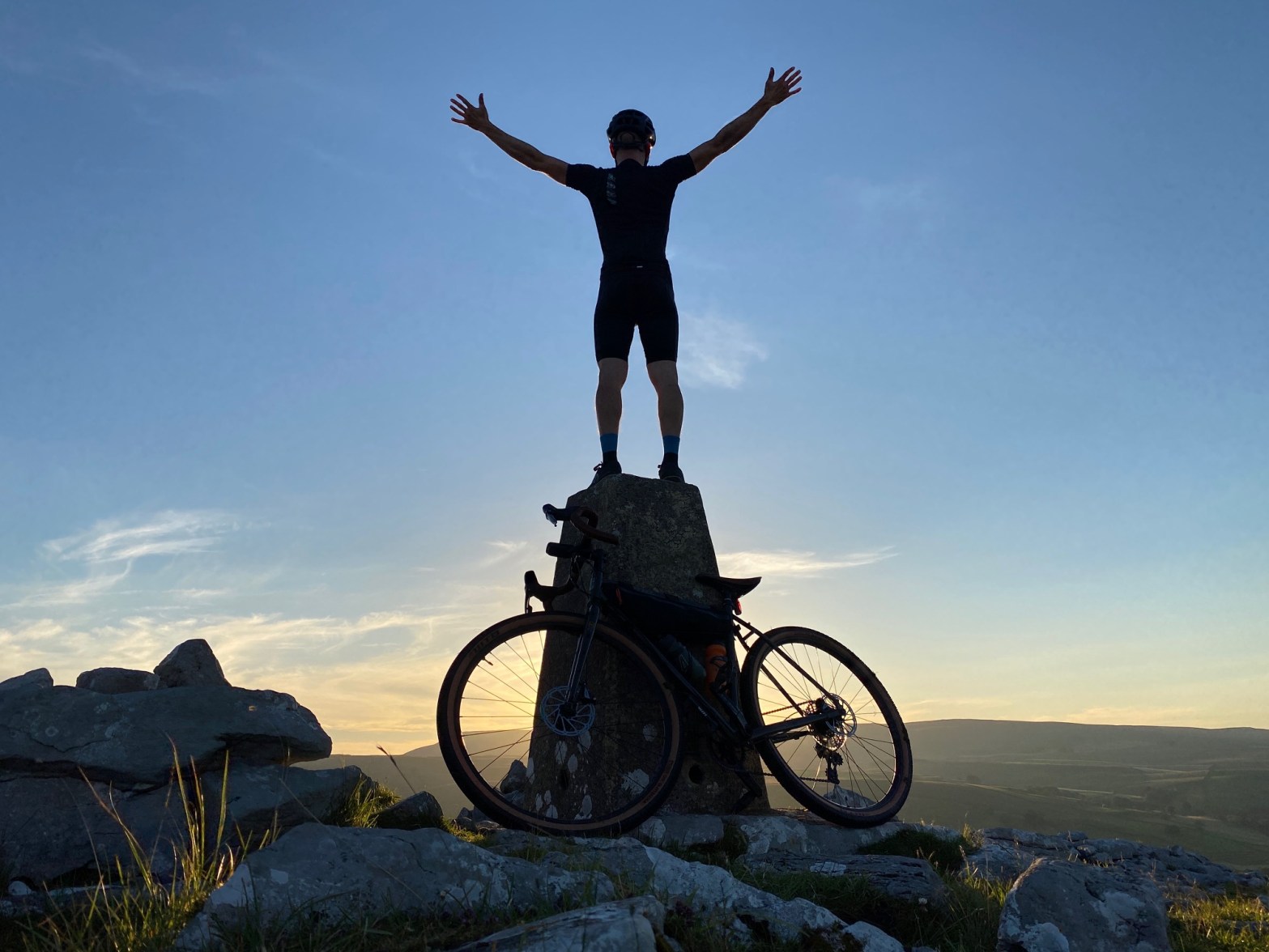
I received more looks of bewilderment from onlookers as I pedaled the bike to the trig point and took my pictures. I reached the summit of Ingleborough (723m or 2,372 ft) in just under four hours since my last trig point. The panoramic views from the top were incredible. The wind, more than a soft breeze threatening to blow my bike out of my hands, the lush Yorkshire valleys below created by historic floods now filled with wildlife blossomed in the now late morning sun. it was a special feeling. The sense of achievement overwhelmed me a few seconds before I looked at my map. Again, I had to get down the same way I got up.
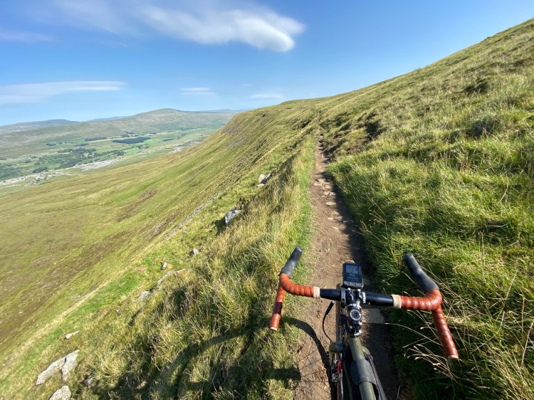
Once again, with the bike on my back, I started to make my descent. A passing walker asked me which route I was taking, noting that one of them was not advisable due to it being so sodden and as an experienced walker would strongly advise against it. Well, guess what. Turns out that was my route.
The sharp descent made it exhilarating and scary, wide enough only to fit my bike at times and had a sheer drop on one side of more than 100ft. I had to keep calm and focus, the bike was now skipping gears and I didnt have space to jump off to look at it so I plowed on using only one gear. On my way down, I reached my fourth trig of the day. I took my pictures and continued descending down through the farmland. The track was so steep it was more like riding a competitive downhill MTB race against myself. I weaved down the mountain from left to right, skidding my way down the saturated ground down the next road. The road, leading to my car.
I reached the car at around 1:30pm. Myself and my bike covered head to toe in mud, my back aching from the hiking, my arms feeling like they’re ready to be shook away from my body, my legs feeling as though I had ridden for a solid 100-200 mile ride. I was beaten up. However, I wasn’t ready to give up. I decided I would climb another of Yorkshire’s Three Peaks and then make a decision. Pen-y-Gent was my target and after a short break, I set off.
My bike, however, decided to call it a day. The noises, more regular now or maybe it was more noticeable as I was on flat tarmac roads. The gears skipping at every opportunity. I stopped and tried to index but it wasn’t possible. My lightest gears, used for climbing, wouldn’t work, there was a larger issue afoot.
Beaten, battered, bruised and covered in mud, I was defeated in the Trig battle.
I loaded the car and took the bike to the local bike shop who proceeded to tell me I shouldn’t be riding on it. Turns out, due to all the riding and the 42,000 ft of climbing I have done recently I was more than my legs that took a battering. My chain was about to snap, the tension created in climbing the great Yorkshire Mountains had taken its toll, my cassette, trying to keep up with the changing tension had seen a lot of better days and the only remains of back brake pads were but a whisper and my bottom bracket was barely but a dream. I booked the bike in to be repaired, cringing at the thought of another bike bill and headed home.
Looking back on this day, I was quite disappointed at the time. I really thought I had a chance of making it to at least 15 trigs. However, upon reflection and removing the fact I now have a looming bike bill, I feel positive, I am putting it down to one hell of an adventure and a learning experience. I only wish I had taken more time to enjoy the views and taken more pictures and videos.
The things I will take away most from this are that route planning, route knowledge and attention to detail with bike maintenance should not be overlooked and if anything more time should be spent on each of these over the course of many days before an event. Not two days before.
It is not enough to trust applications alone. Whilst they’re wonderful and helped me plan a good outline of a route, I should have spent more time researching the route and making each section more adaptable for unforeseen circumstances such as thunderstorms the night before etc. The time I spent traveling from trig to trig via farmland, was on its own a huge expense. Not only in time but in effort and energy. My time would have been better spent traveling on roads in between these.
Listening to the advice of bike racers such as James Mark Hayden (2x winner of the Trans Continental Race) would have been a great start. In Jame’s recent podcast with Bikes or Death (I highly recommend this podcast!) he talks about his meticulous planning when it comes to routes, sometimes creating two or three routes per section. I remember listening to this podcast and feeling inspired. However, somewhere along the line I forgot to put it into action. It won’t be happening again.
Or maybe I am taking it too seriously. It’s just a bike ride after all and hell, I had a great time and have made some great memories!
I have also now acquired a new personal challenge. Once I get my bike back, to attempt to ride the all of the Yorkshire Three Peaks in 24 hours. An achievable ride, one that includes much of the riding or should I say, hiking of this day but with some better planning one I am confident in completing.
Ride by the numbers
41.4 Miles
5:41 Hours of Riding
4,639 ft Elevation
4359 Calories
View ride here

Amazing effort. You definitely should stop and enjoy the views. It’s amazing how much it recharges you as well just stopping. I’ve found that if you don’t stop you end up burning yourself out much soon and making mistakes. Looking forward to seeing your 3 peaks attempt 🙂
— Chris
LikeLike